Mt. Everett

Western Massachusetts has several notable mountains. The highest mountain in the state (Mt. Greylock) is there. More interestingly, Mt. Frissell, whose southern slope contains the highest point in Connecticut (Bear Mountain, the highest peak in CT, is about 50 feet lower) is in the Southwestern corner. There is another summit nearby that induces the exact same reaction from every single person. That mountain is Mt. Everett. [pause for audience pun] No, Mt. Everett.

INSERT_MAP

The hike from Jug End Rd in Great Barrington to the peak of Mt. Everett is a moderate 9.2-mile round trip (it took us just under 6 hours). The beginning of the hike features some rock scrambling and some confusing switchbacks. Enough people have missed the switchbacks that the ground is worn in a trail-like manner going in the wrong direction. For the first mile or so, make sure to pay careful attention to the white blazes. You’ll get to the top of a ridge that would have had some great views if it wasn’t the hottest, humidest, haziest day of the year. At about the 4-mile mark, you arrive at Guilder Pond, a really fantastic swimming hole. If it’s a hot day, bring a pair of trunks and a towel and a water filter. You’ll be glad you did. (We didn’t.)

The top of Mt. Everett is actually pretty dull. The fire tower was torn down in 2003, and all that’s left is the foundation. By the time you get to the pond, you’ve already climbed most of the way up. The 360-degree view looks like it’s probably pretty great on clear days.

Note: I realized the other day that M and I do a whole lot of hiking. I want to start writing up some of them here 1) for posterity, 2) for future reference, and 3) so you and random Googlers can use our experience to plan hikes.

Dear Plutor of the future

Dear Plutor of the future: I know that the crumbling economy, skyrocketing gas prices, and warming climate trend has likely made the world of 2008 a bleak Mad Maxian landscape. If the grocery stores are even open anymore, the selection is likely poor – jicama and tomatillos being among the very few surviving produce. But I have good news for you. I know of a place where, ideally in August, you can pick and eat delicious ripe blackberries until you explode. I will leave the task of fashioning a boat out of household materials to you[1] – I’m certain that as the world spun towards chaos, the last issue of Make Magazine was particularly helpful. You’ll need to boat straight out from the end of South Boston to Spectacle Island. Once there, hope that the trails have not yet been completely overgrown, and follow them to the north drumlin. Along the path, you’ll see the plants, but the mother lode is just before you get to the hilltop, on the left.

Bring a few containers. And good luck.

[1] - I don’t envy you this task. In 2007, there was a Ferry that you could pay $12 to bring you to Spectacle Island and the many other harbor islands. It was fun for a number of reasons other than the fruitful bounty.


Katahdin report

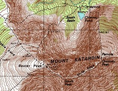
Mount Katahdin has rightfully earned its reputation as one of the hardest mountains in the Northeast. M and I hiked it last week, planning about a 7-mile day. We got up at 7 to read the weather forecast on the Ranger’s cabin, and hiked the 3.3 miles to the Chimney Pond campsite in the south basin. We dropped off our tent, sleeping stuff, clothes, and one of our packs. Around 10am, we started up Pamola trail. It was 1.3 miles and 2000 vertical feet up that trail to our first peak.

Katahdin map

What we learned is that the trail up Pamola is perilous, windy, totally exposed, ridiculously steep, and covered with pointy and scratchy boulders. We rock scrambled at a 45 degree angle hundreds and thousands of feet above the foothills for nearly three hours. Yes, that’s right, it took us three hours to climb a mile and a third.

At the peak, we reconsidered our options. We were tired. No, wait, we were exhausted. We agreed that it very likely had been the hardest hike of our lives, and it was shorter than the distance from our house to Boston Common. Coming up was the most notorious stretch of trail on Katahdin: the Knife Edge. It’s a rocky trail about three feet wide at parts the follows a sharp ridge between Pamola, Chimney Peak, South Peak, and the top of the mountain: Baxter Peak. After some math, we took the optimistic route: continue the plan.

We started heading to the opposite side of the peak, and then we saw it. Not just the Knife Edge, but the first hurdle on it: the Chimney. A 200 foot precipitious drop that we needed to rockclimb down and then the same on the other side to get back up. But we weren’t ready for it. We tried a couple different ways down, struggling against tired muscles. We sat staring at it, weighing our other options. It cut a deep groove directly between Pamola and the rest of the peaks, so we couldn’t go around.

We were beaten by Katahdin. We turned around, heading back down Pamola trail, and the whole way down we had to hope we wouldn’t fall off the pointy and scratchy boulders.

INSERT_MAP


Shenandoah National Park (National Park Service)

M and I just got back from a four-night trip to Shenandoah National Park in northern Virginia. I’ve been talking about it with people this week, and I’ve run out of positive adjectives. It was remarkably amazing in every way.

INSERT_MAP

Most of our trip we spent hiking: 7 or 8 miles each day. Since we generally hiked from trailheads on Skyline Drive (the main 105-mile road running through the center of the park and the roughly along the ridge of the Blue Ridge Mountains) to waterfalls, just about every single one of the hikes was down for several miles, then back up. Which was a strange thing to get used to. The trails were probably the best-marked ones I’ve ever hiked on. Every mile or so, there would be a granite post in the ground with a metal band around the top. The band would say what trail you were on and how far to other side-trails and destinations and whatnot.

The lodge we stayed in (Skyland) was great (and the view from the room was outstanding). And the “Early Bird” special package (for going before their busy season) was really fantastic. The weather could not have behaved any better while we were there. Move-related problems meant we didn’t have our digital camera with us, but the photos we took with film and my cellphone are definitely excellent.

I recommend this trip for anyone. The lodge meant you didn’t have to really be roughing it, but there’s more than 500 miles of hiking to a whole lot of great mountaintops and waterfalls. There’s 75 stunning overlooks along the road alone, so if you’re not even in a hiking mood, a drive through the park is also more than worth the time it takes.